


- Orbital Insight Blog
- Demystifying Geospatial Intelligence
Blog
Demystifying Geospatial Intelligence

Why is Location Analytics Important, What can you do with it, and Why Should You Care?
The global geospatial analytics market is estimated to be $59.5 Billion in 2020. It is projected to generate $158.84 Billion by 2027 according to Allied Market Research. While the interest in this discipline is proliferating, yet a vast majority of organizations don’t leverage geospatial data, and many struggle to understand this fascinating technology. In this blog, we will discuss a few common questions that potential customers may have in mind. If you have never heard about geospatial analytics, perhaps considering it, or are just curious about how augmenting your analytical stack with a geospatial component can provide a substantial competitive advantage, this blog will acquaint you with geospatial technology. Here are the most frequently asked questions about Geospatial Analytics:
What is Geospatial Intelligence?
The National Geospatial-Intelligence Agency (NGA) defines Geospatial intelligence, or GEOINT, as the exploitation and analysis of imagery and geospatial information to describe, assess, and visually depict physical features and geographically referenced activities on the Earth. GEOINT consists of imagery, imagery intelligence, and geospatial data. Although started as a project by the US military, today, the technology is being used across several industry verticals from real estate, financial services, manufacturing, and many more.
Why does Geospatial Analytics Matter? Isn’t it meant for defense and the military?
Every day, companies, investors, and governments make critical decisions without accurate information about what’s happening in the world. These decisions can change the trajectory of our economy, the environment, and national security. Geospatial analytics enables organizations to understand what’s happening on Earth so they can make better decisions with accurate, current information.
For example, multinational companies set production schedules and pricing without sufficient visibility into their supply chains and competitors. Real estate companies invest billions in projects without understanding the behavior and demographics of local communities. Under pressure to operate sustainably, CPG can’t verify whether suppliers of foundational materials like palm oil are harming the environment. Governments allocate trillions in services, security, and humanitarian aid without analyzing data at the speed they need.
What are the applications and use cases of Geospatial Analytics? Where can you apply Location Intelligence?
Geospatial analytics can be used in many industry verticals. Here are the most common examples and use cases:
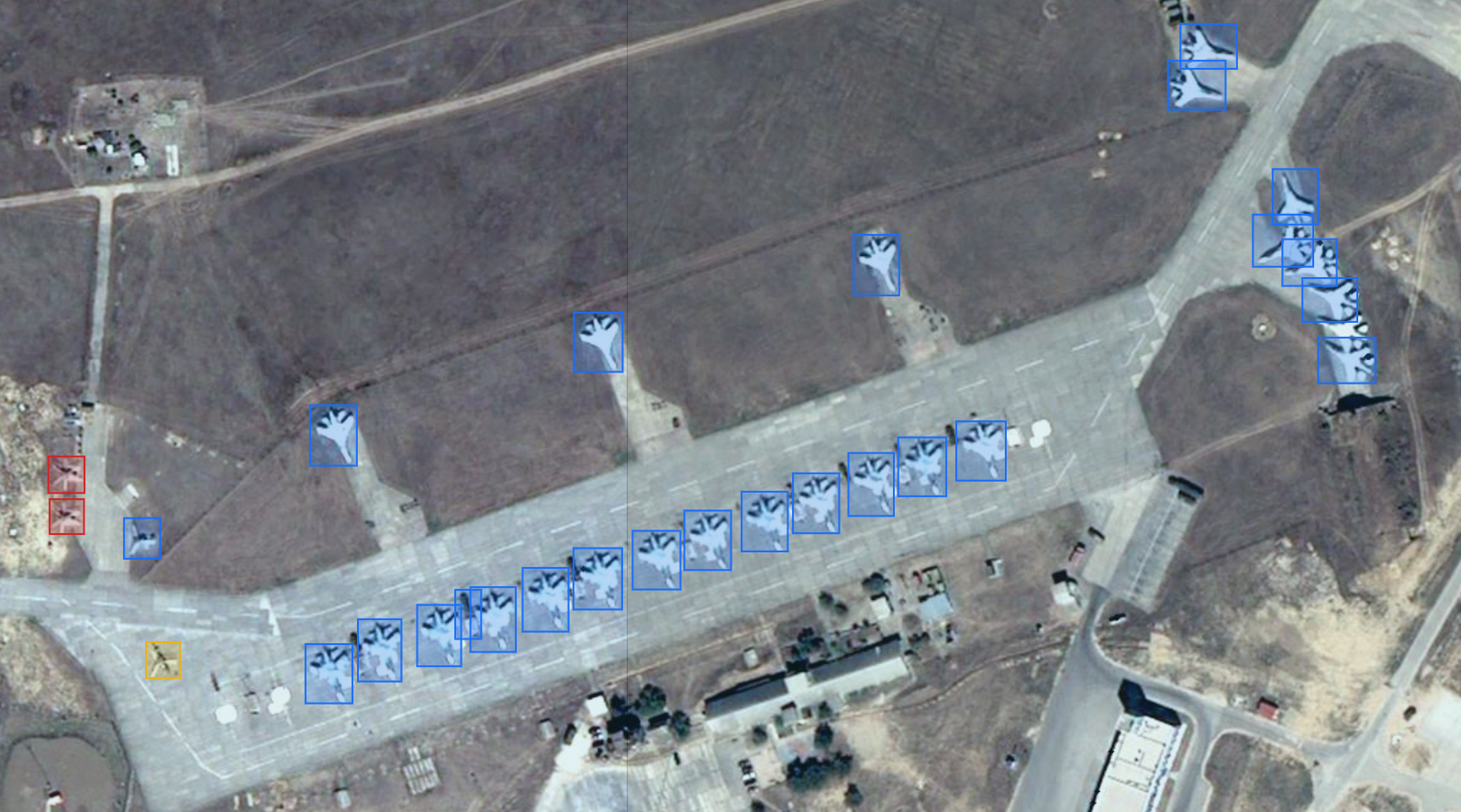
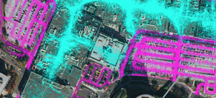
1. Defense, Intelligence, and Military - The most common application of GEOINT is in the defense and military space. We can detect and classify particular objects over large-scale geographies or areas of interest with automated processing and analysis of satellite or UAV-derived imagery with automated processing and analysis of satellite or UAV-derived magery. By using computer vision algorithms, it is possible to perform object detection and identify:
- Planes: Fighter, Bomber, Helicopter, Other military planes, Large & small commercial planes
- Vehicles: Cars, Trucks, Railcars
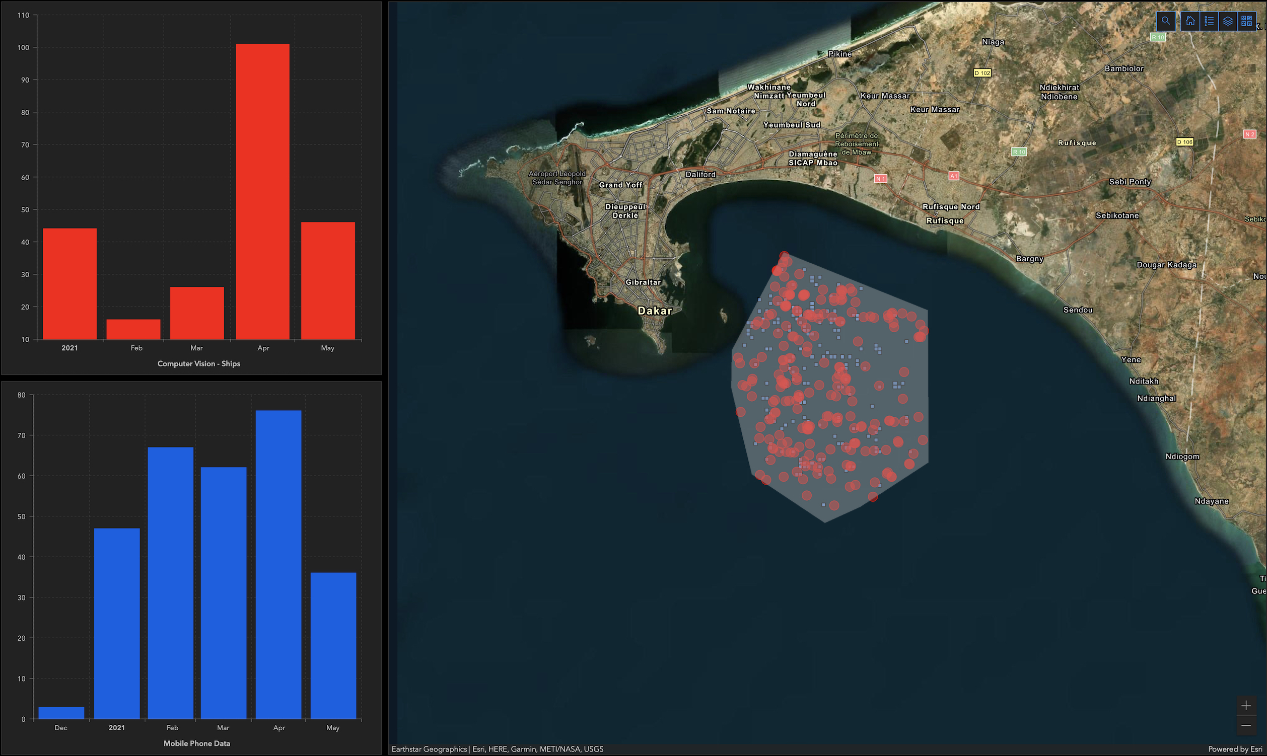
- Ships: Aircraft carrier, Military warship, Submarine, Cargo ships, Cruise ship, Tugboat, Other large & small ships
Here is an example of applying computer vision for railcar detection covered in the previous blog.
2. Real Estate & Financial Services - By applying artificial intelligence to anonymized location data, an advanced geospatial analytics platform can provide a better understanding of the travel patterns in and around shopping malls. It can also show how activity levels have fluctuated due to the pandemic and the restrictions put in place to minimize the spread of COVID-19. Using cell phone geolocation pings to analyze the number of trips between any two areas of interest over time over time. For example, our customer Avison Young recently launched an interactive dashboard, the Vitality Index, that measures the pace of return to downtowns by leveraging Orbital Insight’s geospatial analysis. The vitality index is an office occupancy index across regions and industries that has the potential to become the most important metric in the office real estate space. Everyday use cases in the real estate, retail and financial services verticals include:
- Quantify cross-shopping at competing stores or properties over time to measure trends in customer loyalty
- Seize opportunities for redevelopment or increased parking capacity by identifying consistently underutilized or crowded parking lot sections
- Measure foot traffic at shopping centers and retail stores as an input to estimating sales
- Count visitors to hotels, restaurants, casinos, or theme parks to gauge occupancy
- Analyze devices that visit shopping centers, retail stores, theme parks, hotels, etc., to find out where they are coming from and going
- Look at where devices that visit a particular site work and how that has changed over time
- Use devices’ home regions to compute weighted average demographics such as income, gender, age, etc. of visitors to a specific property or group of locations
- Analyze workers at construction sites, financial centers, etc. to know where they are commuting from to get to work and how those areas have changed over time
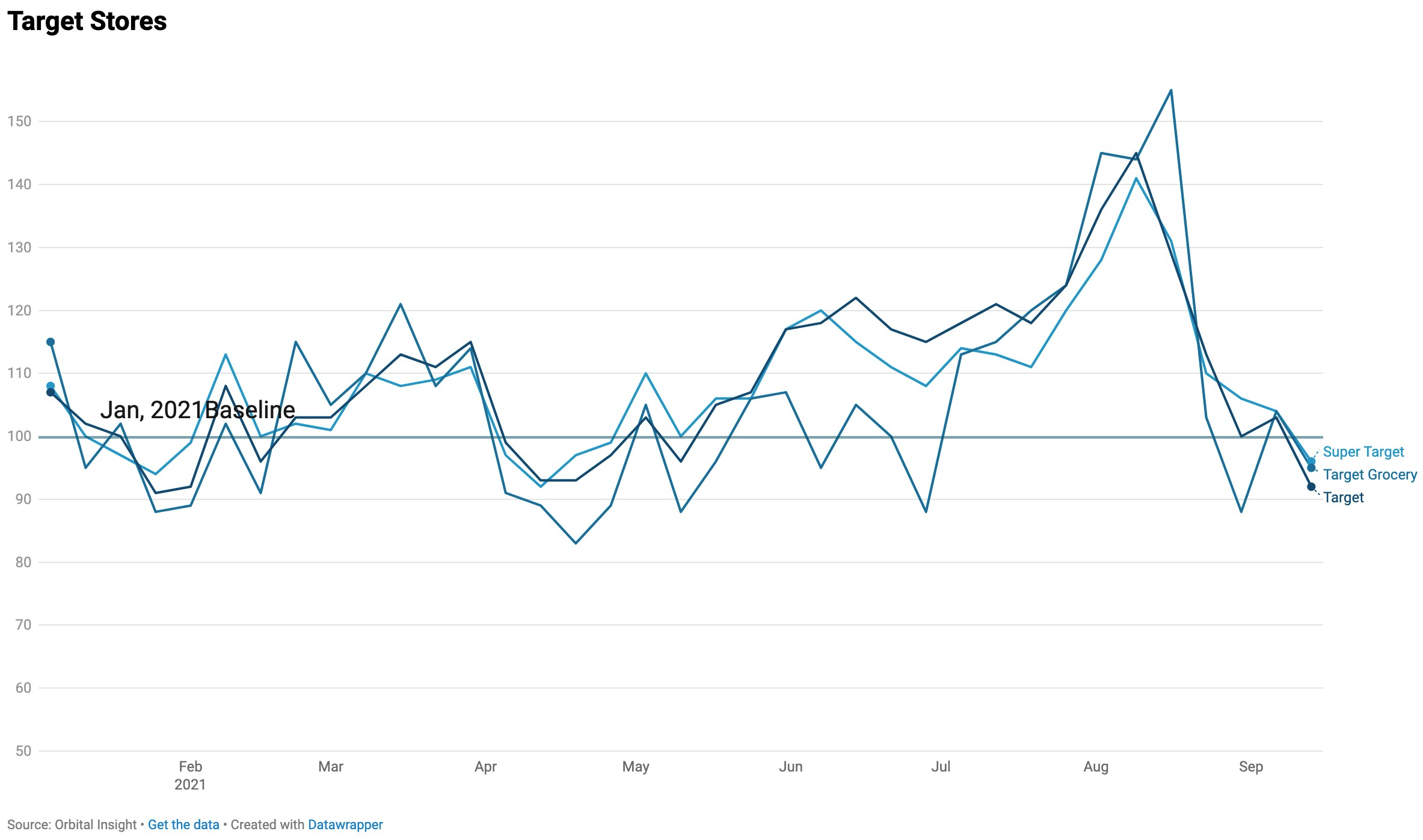
Blomberg recently covered how the city of London is finally getting back to the office based on foot traffic analysis. Across the City of London, foot traffic was estimated to be 39% of the pre-pandemic norm on Sept. 15, according to an analysis by Orbital Insight, which monitors activity levels through satellites and mobile phone data.
3. Manufacturing & Supply Chain
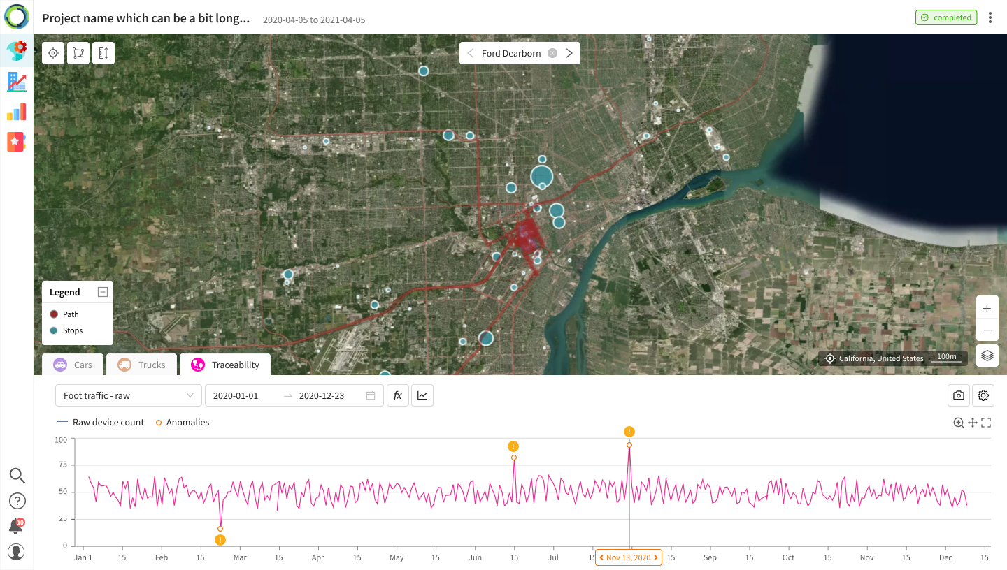
Supply chain visibility and traceability have become critical in manufacturing especially in JIT production. Supply chain leaders need to understand anomalies, outages, and disruptions at their suppliers, both direct and indirect, and your competitors. Geospatial analytics and location intelligence increase supply chain visibility, enhance traceability, and improve operational efficiency. By combining satellite imagery, computer vision, and multisource (IoT) data, an AI-powered geospatial platform can monitor daily activity levels, perform anomaly detection and reduce disruption risk.
- Measure the count of devices at product-specific plants as a proxy for worker activity & production
- Count devices at mining sites to estimate levels of output for certain materials
- Measure device counts at warehouses and fulfillment centers to measure company or regional throughput of e-commerce deliveries
- Use AIS (ship location) data to quantify the inbound & outbound traffic to specific ports as an indicator for the supply of a particular product or to a specific region
- Monitor facilities, properties, groups of locations, or regions to identify statistically significant increases or decreases in expected foot traffic for real-time strategic decision making
- Visually identify where devices are concentrating to determine what equipment maintenance crews are working on at a plant or manufacturing facility
What are the challenges when dealing with geospatial data?
According to the Outer Space Object Index, maintained by the United Nations Office for Outer Space Affairs, there were 7,389 individual satellites in Space at the end of April, 2021; an increase of 27.97% compared to 2020. There's now an abundance of satellite imagery available, with the addition of nanosatellite constellations that are imaging the Earth daily with 90-minute orbits. That makes it impossible to manually analyze the economic, environmental, and societal trends within each pixel and compare them to historical imagery. Because of this data deluge, organizations must choose to focus on applying artificial intelligence at scale, automating geospatial analyses to understand global trends as they occur.
At Orbital Insight, our GO platform can ingest, interpret and analyze petabytes of geospatial data from a vast array of sources. These include electro-optical satellite imagery, synthetic aperture radar, unmanned aerial vehicles, connected cars and other IoT devices, AIS, and geolocation signals. The GO platform applies proprietary data science and computer vision algorithms to contextualize this raw data into actionable information, allowing investors, corporations, and governments to mitigate risk and identify opportunities at scale and in near real-time.
Orbital Insight provides the fastest and easiest way to use geospatial data to answer your organization’s questions. Our platform enables you to Discover, Measure and Monitor activity around the world to make better-informed decisions. Would you like to learn more? Check out how our customer RBC is using Geospatial-Intelligence to uncover the constraints hampering the global container shipping industry in this latest report from RBC:
Recommended for You
-
-


Dec 14, 2021
Advancing Intelligence, Surveillance, and Reconnaissance Applications With Computer Vision
Learn More -

