


- Orbital Insight Blog
- The role of geospatial analytics in defense and intelligence
Blog
The role of geospatial analytics in defense and intelligence

Geospatial analytics makes intel analysts more effective, enhances national security, and radically transforms defense capabilities
AI and advanced analytics applications have improved the throughput, efficiency, safety, and reliability of industrial operations. Heavy engineering industries such as metals & mining, chemicals are adding connectivity, automation, and data analytics as part of the digital transformation initiative. What role can AI play in the public sector? How will digitalization impact the operations of aerospace and defense contractors, particularly the critical defense supply chains? And more importantly, will the advent of AI in the military and defense community spur innovation and bring strategic advantage on the battlefield?
Based on industry data, one thing is clear - aerospace and defense companies need to double down on digital initiatives. There is growing evidence that companies with digital, flexible supply chains experienced fewer production delays in the pandemic. But are defense supply chains prepared to respond to supply shocks? Unfortunately, the answer is no, and it is no surprise that lawmakers are putting pressure to treat supply chain security as a strategic priority.
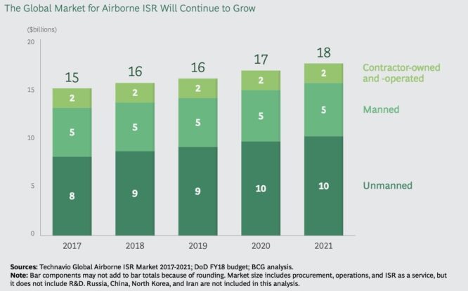
But, beyond supply chain transparency and traceability, AI has tremendous opportunities in the defense sector. One example is the airborne intelligence surveillance and reconnaissance (ISR) sector. According to a recent report from Boston Consulting Group, the ISR is one of the fastest-growing segments of the defense industry. Consequently, new platforms are emerging to meet the requirements of the military.
AI for Defense & Intelligence
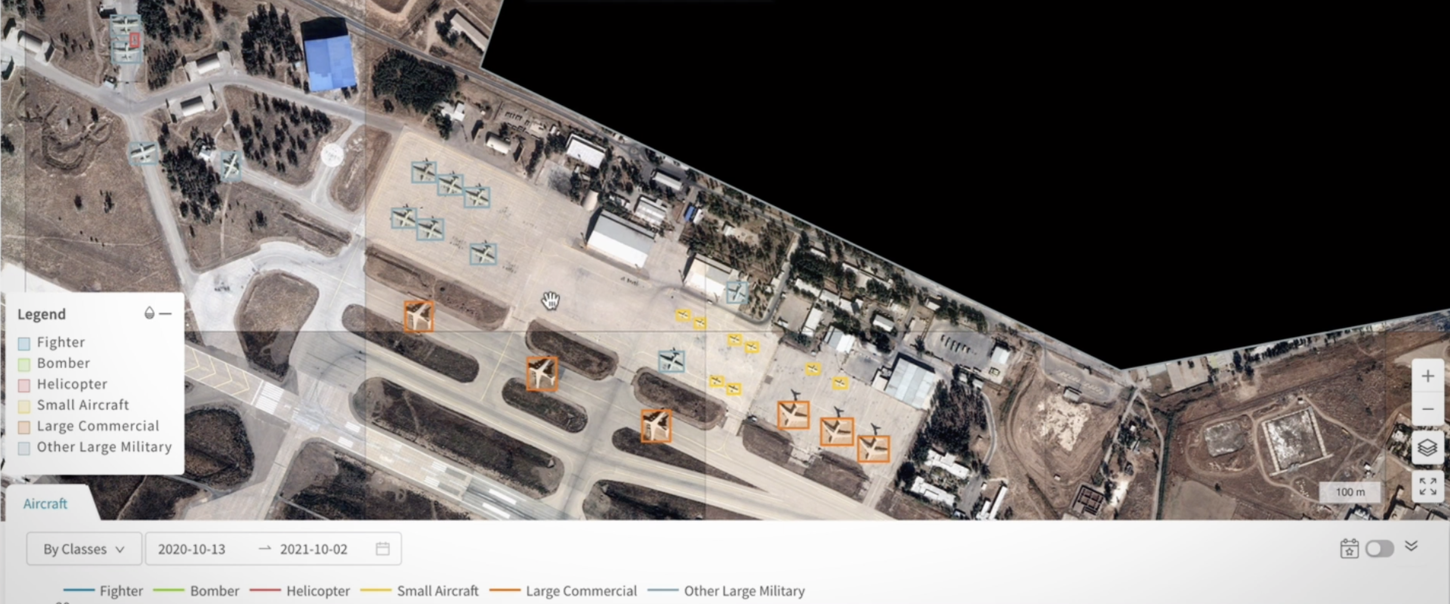
In the defense and intelligence industry, dedicated analysts monitor imagery from earth observation satellites. The intelligence analysts are often drowning in data, monitoring multiple data sources simultaneously, looking for insights. Depending on the area of interest, they have to look at many variables. For example, image analysts look at hundreds of samples of satellite imagery of the same site around the same time every day, trying to identify any unusual change or spot new objects. With the proliferation of ISR technology, there is so much data flowing from surveillance aircraft, UAVs, high altitude balloons, imagery and SAR satellites, etc. These image experts can’t do the analysis manually anymore—they need automation tools to constantly monitor known locations and alert the analysts when the usual pattern of life changes.
Intelligence and military operations require a scalable, robust, and high-performance environment for data management, review, and analysis. Military analysts need tools that will enable them to perform better during missions. They need to analyze situations quickly, detect anomalies based on ever-changing data, and identify patterns that demand immediate attention. That’s where AI can help. Computer vision algorithms can take on the workload and analyze thousands of images, detect changes, and notify analysts automatically. With the right geospatial platform, automated analysis of satellite imagery is possible anywhere on the planet and at scale. An AI-Powered analytics platform can simplify the data science workflow for analysts by preprocessing data, cleansing the data, and applying relevant algorithms for object detection, anomaly detection, or predictive analytics. The confluence of AI, location analytics, and computer vision in the military and defense world is creating tremendous opportunities with use cases for target detection, airbase monitoring, and wide-area activity monitoring.

The Challenges
The applications of AI and machine learning in the public sector, while promising, are also challenging for various reasons. There are concerns around model accuracy and interpretability. Any revolutionary new technology is going to have its share of problems. However, with time and iterations, technology gets better. In the case of AI, the advantages outweigh the disadvantages. AI is enabling experts to do their job more accurately and efficiently. The goal is not to replace analysts with AI but to augment human performance with intelligent tools. The idea is to use automation for repeatable tasks, technology to monitor a large number of areas, and algorithms to perform object detection with automated alerts for the analyst to investigate. Explainable AI allows domain experts to understand the data science process and gives them the ability to explain how the model is working.
Actionable Insights
An AI-powered geospatial platform designed and purpose-built for defense intelligence and military needs can boost the productivity and efficiency of analysts. A collaborative system built on the human-in-the-loop paradigm brings the best of both worlds - the efficiency of intelligent automation and the knowledge of subject matter experts. This approach allows analysts to leverage their domain expertise by providing relevant facts to enrich data and train AI systems. Then, by using the latest computer vision algorithms, the system finds patterns in the real-time data, performs anomaly detection, and empowers analysts to act on the insight. Using an abstraction layer, the platform simplifies the usage, hiding complexities, automating feature engineering, and other demanding steps of the data science process. Unlike black-box AI, the platform provides details inside the inner workings making the modeling process transparent. Explainable AI gives insight into data science workflow, allows analysts to explain the model, and enables SMEs to understand which process variables affect outcomes. A sensor-agnostic, geospatial platform offers analytical flexibility to address multiple sources of data and dramatically improves the life of intelligence experts.
The US government, military, and law enforcement communities can leverage AI to analyze situations, detect anomalies and visualize threats globally by using geospatial solutions. Orbital Insight’s GO platform transforms multiple geospatial data sources— satellite images, anonymized location data, ship AIS data, and other IoT data—into objective answers to questions about supply chains, geopolitical events, and military movements. At Orbital Insight, our mission is to understand what is happening on earth and augment the performance of intelligence agencies. And empowering intelligence and defense analysts with actionable insights anywhere on the planet is a massive strategic advantage.
Are you curious about geospatial analytics and how it can help the military improve intelligence gathering and build defense supply chain resiliency? Discover more details at:
