


- Orbital Insight Blog
- Te Hau Ora O Ngāpuhi and Orbital Insight Partner to Understand Tourism and Growth Patterns in New Zealand’s Northland Region
Blog
Te Hau Ora O Ngāpuhi and Orbital Insight Partner to Understand Tourism and Growth Patterns in New Zealand’s Northland Region
Te Hau Ora O Ngāpuhi, an indigenous health provider located primarily in the Northland region of New Zealand, and Orbital Insight have partnered to create a better understanding of how human activity is impacting environmental and economic conditions in the Northland region. Using Orbital Insight’s GO platform, the partnership leverages satellite imagery and AI-derived analytics to better understand the impacts of increased tourism, urban growth, traffic, and residential construction.
Like most regions of the world, official sources of economic data for Northland are published at a lag, irregularly, and usually aggregated at a level less useful to Ngāpuhi decision-makers. With Orbital Insight’s technology, Te Hau Ora O Ngāpuhi receives data in a timely fashion for their defined areas of interest. The data from these areas provide a better understanding of economic activity. Te Ropu Poa, General Manager of Te Hau Ora O Ngāpuhi, sees the following uses:
“Globally, Ngāpuhi is the first indigenous people to partner with Orbital Insight, exploring the way Northland is growing and tracking the amount of traffic entering and exiting the main towns on the tourist circuit (i.e. when, where and how much traffic). Also, the GO platform offers the ability to see what land is used for, including identification of new buildings over time. These new developments will assist Ngāpuhi to make better decisions as they will collect useful data for future planning.”
The partnership supports the following objectives:
- Data Transparency & Reduced Latency: Orbital Insight provides Te Hau Ora O Ngāpuhi with up-to-date foundation data that does not exist in the public domain. Tools like Google Earth images and OpenStreetMap serve as valuable geospatial tools but are often outdated or incomplete in rural areas.
- Scope and Coverage: Using Orbital Insight's automated change detection, Te Hau Ora O Ngāpuhi decision-makers and their staff can track areas of new growth or loss of natural resources not readily apparent to the human eye, particularly at region-wide scale. In this case, the area of analysis includes Northland and the northern portion of the Auckland metropolitan area, totaling over 22,000 square kilometers. This data will be used to study the impact of urban growth on farmland and natural resources, and to track new building construction associated with residential homebuilding and tourism.
- Human Equity: Regions of northern New Zealand are economically disadvantaged. With timely and objective satellite-derived data on tourist activity, construction, and natural resources, Te Hau Ora O Ngāpuhi leadership may make more informed decisions around job training and resource allocation.
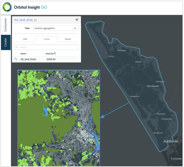
A sample of the land use map from the 22,000 km2 area covered in the Northlands in 2018.
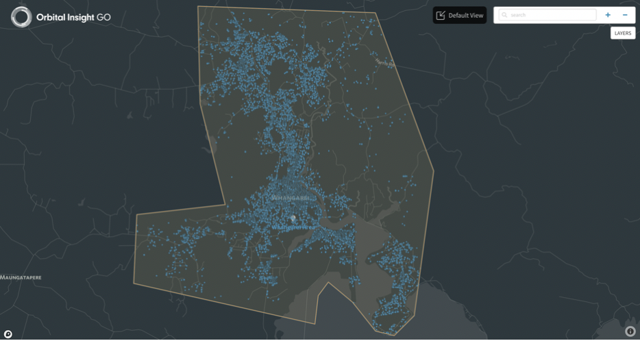
Car detections in the city of Whangarei on a day during 2018. Te Hau Ora O Ngāpuhi is using this data to understand seasonal changes in car traffic at key tourist sites in a half dozen cities across the region.
Work for the partnership began earlier this year and will continue through Spring 2021. Orbital Insight will continue to provide Te Hau Ora O Ngāpuhi with annual land use updates for the region, traffic analyses for select cities and tourist hotspots, and explore new capabilities of the GO platform as the partnership deepens

