


Platform
Orbital Insight GO
The GO Platform
The Orbital Insight GO platform is designed to simplify the use of location data, allowing users to query the world with three basic parameters:
- WHAT type of activity?
- WHERE on earth?
- WHEN?
The AI-powered platform automates the most difficult steps of deriving insights: allowing you to answer many challenging geospatial questions.

WHAT
Our platform allows you to select what you want to measure from our proprietary set of industry leading algorithms.

- Cars
- Trucks
- Mobile Missile Launchers
- Fighters
- Bombers
- Helicopters
- Small Aircraft
- Large Commercial
- Large Military
- Tankers / Container Ships
- Aircraft Carriers
- Warships
- Submarines
- Cruise Ships
- Tugboats

- Roads
- Buildings
- Water
- Forest
- Grass

- Foot Traffic
- Car Traffic
- Ship Traffic
- Movement Tracking
- Traceability
- Heatmaps
From Sensor Data to Insights
Each algorithm is applied to our curated catalog of the best data sources available to ensure the highest possible accuracy, coverage and revisit. Our experts continuously search for new data sources, evaluating their efficacy and negotiating contracts so that you don’t have to.
Beyond finding these data sources Orbital also performs the heavy lifting to clean and process the data, making historical and real time analysis instantly available.
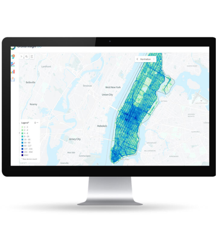
WHERE
The GO platform makes it quick and easy to search, select or draw the areas that you want to analyze. Whether it’s one location or millions.
- Find Areas of Interest from our catalog of more than 3.7 million predefined locations
- Define your own custom areas of interest
- Import areas of interest from existing geographic information files (Shapefile, GeoPackage, GeoJSON, KML, KMZ)
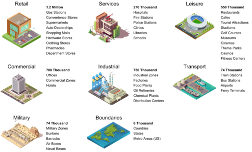
Area of Interest Catalog
To simplify the process of creating areas of interest you can leverage the built-in catalog of 3.7 Million pre-defined polygons of places. The catalog includes a wide range of global areas covering:
- Retail
- Services
- Leisure
- Commercial
- Industrial
- Transportation
- Military
- Geographic boundaries
Search & Select Areas from the Catalog
Search and select areas by:
- Zooming into geographic region on the map
- Browse by type
- Search by name, type and/or region


Draw Your Own Custom Areas
- Find the area of interest using the search box, or
- Navigate using the map visualization
- Click on the Polygon Tool
- Draw the shape using one or the map layers as support


Import Areas of Interest
Import areas of interest from existing geographic information files, including:
- Shapefile
- GeoPackage
- GeoJSON
- KML / KMZ

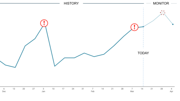
WHEN
GO allows you to select the time period of your choice and run your analysis. The platform helps you understand what historical data is available in our curated catalog and automatically collects ongoing data for continuous monitoring.
Orbital’s AI automatically understands normal “patterns of life” and notifies you of anomalous activity.
Date Range
- Analyze historical data, going back multiple years
- Continuously track changes in near real-time
- Automatically monitor for anomalous activity
Time and Velocity Filters
Fine-tune what type of activity you care about, including:
- Dwell Time: e.g. Pop-in's, Visitor, Full-time workers
- Hours of Day: e.g. Morning, Daytime, Evening
- Days of Week: e.g. Weekday, Weekend
- Velocity: e.g. Stationary, Walking, Biking, Driving (Flying - not really)

How our Customers use GO
We provide multiple ways for our customers to flexibly leverage the GO platform.
Orbital Insight Application
The GO user interface allows you to easily walk through the What > Where > When steps to create, analyze and export results.
Enterprise API
Easily integrate into existing workflows, databases, business intelligence tools, or geographic information systems.
Professional Services
Have our team of geospatial engineers build custom workflows and apps to better fit your needs.The GO Platform Benefits
The GO platform is designed to answer global questions and global questions require global scale and performance to match.
Learn more about the benefits of the GO platform.
How can we help you?
Drive better business and policy decisions by contacting us today.

Contact Us
Fields containing * are required.